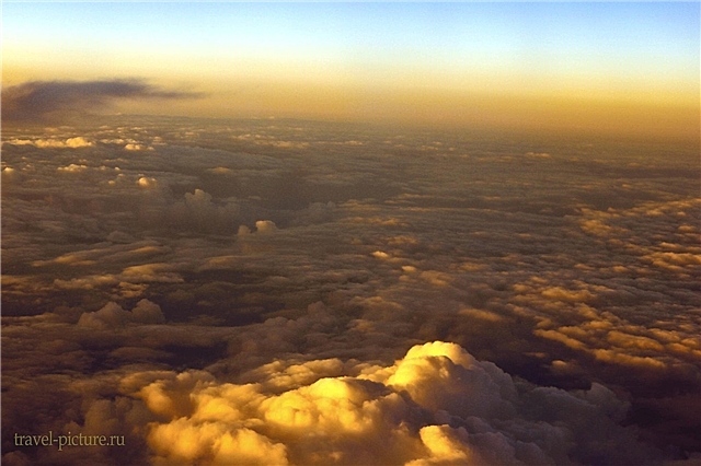
Tourists associate Kamchatka primarily with natural features. There is a huge variety in this direction at the edge: waterfalls, hills, volcanoes, parks, hot springs and much more. They are scattered throughout the region, making it difficult to see everything in one trip.
People come to Kamchatka to enjoy incredible views and clean air. However, on the way to the picturesque geysers, beaches and bays, it is worth stopping at one of the museums. For the most part, they are a short but succinct excursion around Kamchatka. Thanks to the museum collections, you can cover several attractions at once and select those that are worth visiting later. The region is able to surprise even inveterate travelers.
The most interesting and beautiful places in Kamchatka
What to see and where to go? The best objects of tourism and active recreation!
Kronotsky reserve
Founded in 1934. The area is over a million hectares. Receiver of the Soboliniy Reserve. Located in the eastern part of Kamchatka. Main objects: volcanoes, including Kronotskaya Sopka, the Valley of Geysers, waterfalls, thermal lakes. Stone birch forests cover most of the area. The vegetation around Kronotskoye Lake is changing: larch, spruce, Japanese birch. Poplar, alder, linden grow near the rivers. Fauna: bears, moose, sables, whales and others.

Valley of Geysers
Part of the Kronotsky Nature Reserve. The geyser field is the only one in Eurasia. On the territory of 6 square kilometers there are mud volcanoes, geysers, lakes, thermal springs, rivers, waterfalls. Landslides and mudflows are a common process in the valley, affecting the microclimate and the number of neoplasms, the number of which is growing every year. Tourists' access is limited. Helicopter tours are available.

Commander Islands
The reserve was founded in 1993. Covers approximately 3.5 million hectares. Consists of 4 large and about 60 small islands. The flora is represented by 400 plant species. Fauna: 25 species - mammals, 170 - birds, 250 - fish. Beloshey goose, sea otter, gyrfalcon and others are included in the Red Book. Historical attraction - the grave of the navigator Bering next to the parking lot of his expedition from the middle of the 18th century.

Klyuchevskaya Sopka
Active layered volcano. Located in the east of Kamchatka. Belongs to the Eastern Ridge mountain system. The crater is 2210 meters in diameter and 340 meters deep. The highest point is more than 4.8 thousand meters from the base. There is a volcanological station at the bottom. The last eruption is dated 2017. One of the most active volcanoes in Russia. The highest hill outside the Caucasus.

Maly Semyachik volcano
Located in the east of the peninsula. Belongs to the Eastern Ridge. The layered volcano has been dormant for over 60 years. The crater is oval, about 800 meters in diameter and 300 meters deep. The highest point is 1560 meters from the base. The volcanic lake of Maly Semyachik is named Green. The reason is the color of the water in the corresponding color. The acidity of the water is one of the highest in the world.

Avacha Bay
Opened in 1729. Part of the water area of the Pacific Ocean Bay of the same name. It is located in the southeast of Kamchatka, on its shore is the city of Petropavlovsk-Kamchatsky. Does not freeze throughout the year. The main port of the peninsula. Both fishing vessels and cargo vessels are served. The total area is 215 square kilometers, the average depth is about 9 meters. Can accept any existing ship in the world.

Rocks Three Brothers
They are located at the very entrance to Avacha Bay in the southeast of the peninsula, three hundred meters from the coast. They are three rocky pillars protruding from the water. Nearby there are strong currents and a canyon at a depth of 13 meters with a cave. Known since the 18th century. Legend has it that these three defender brothers fulfilled their duty to the bay - they saved them from the big wave, and then turned to stone. The symbol of Petropavlovsk-Kamchatsky.

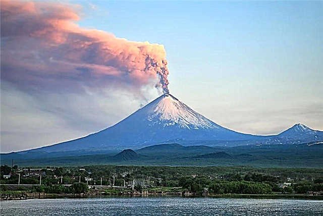
Tolbachik
Volcanic massif belonging to the Klyuchevskaya group of volcanoes. Located in the east of the peninsula. Refers to the shield type in shape. The massif includes Ostry and Plosky Tolbachiks. The crater diameter is about 3 thousand meters. The highest point is 3682 meters. The last eruption took place in 2012. The summit of an extinct volcano is collapsed. Cracks are visible on the surface, a glacier is located nearby.

Dead forest
It is located in close proximity to Tolbachik and was formed after a large eruption of this volcano in the mid 70s of the last century. Lava and rock outbursts have turned the area into a scorched desert. The approximate area of the forest is 40 square kilometers. The ash and slag layer is still mixed with the soil. The trunks of the trees remained black and lifeless. Now there are rare and small islands of greenery.

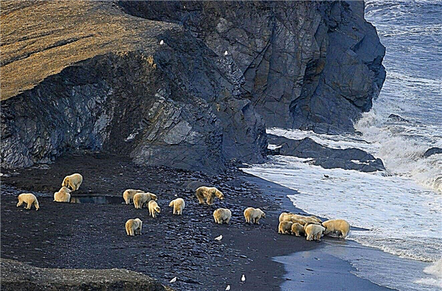
Kuril lake
Located in the southern part of the peninsula. Refers to the territory of the reserve. The first mention is in 1740. The area is 77 square kilometers, the average depth is about 195 meters. Several rivers flow in, one flows out - Ozernaya. The water level fluctuates depending on the season. There are small islands. Sockeye salmon come here to spawn. There is a brown bear in the district: the livestock off the coast is about two hundred individuals.

Blue Lakes
A system of lakes located in the southeast of Kamchatka. Refers to a natural park. Three lakes are in close proximity to each other and are connected by streams, surrounded by hills. The name comes from the color of the water when the snow melts: the level rises and the ice, which is flooded, reflects light in a special way. Along the banks, both large trees, such as cedar, and small bushes of blueberries, saxifrage, and so on grow.

Caldera of Uzon volcano
Located on the territory of the Kronotsky Nature Reserve in the eastern part of the peninsula. The highest point is 1617 meters. The area of the caldera is 100 square kilometers. One of the craters became the site of the formation of Lake Dalniy. There are also other lakes. Those in the western part are mostly swampy. There are about a hundred mineral springs. Some of the algae and bacteria found here are used to living in boiling liquids.

Avachinskaya Sopka
It is located in the southern part of the Eastern Ridge. An active volcano, the highest point is 2741 meters. The top is in the form of a cone, it is covered with layers of lava and slag. The crater diameter is 400 meters. There are many cracks and holes on its surface. The last time he was active in the early 90s of the last century. There is a research station at the bottom. Stone birch and dwarf cedar grow on the slopes.

Karymskaya Sopka
Belongs to the Eastern Ridge. An active volcano, the highest point is 1468 meters. The top looks like a truncated cone. Formed in the basin of an ancient volcano from lava, ash and other components. Gases are released on an ongoing basis. An active volcano, last erupted in 2014. The ashes are scattered over a distance of several hundred meters. Karymskaya volcano wakes up neighboring volcanoes by a chain reaction.

Mutnovskaya Sopka
Located in the southern part of the peninsula. An active volcano, the highest point is 2322 meters. The last eruption is dated 2000. At the same time, gases and smoke periodically come out of the slots and holes. There are hot mineral springs nearby, called the "small valley of geysers". In 2018, a lake was discovered in the funnel, which is not typical for such volcanoes.

Natural park "Nalychevo"
Founded in 1995, it is located in the valley of the river of the same name. The area is 287 thousand hectares. There are several large volcanoes around.Features and places of interest: mineral springs, both hot and cold, with medicinal properties, unique flora and fauna - some of the species are listed in the Red Book, a nature museum, a monument to the Kalashnikov assault rifle, a center for environmental education.

Klyuchevsky natural park
Located in the east of the peninsula. Refers to the territory of the forest fund. On its territory there are more than a dozen volcanoes of different types of origin. The eponymous volcano is the most active in the world. Its height is unstable due to solidifying lava. Each side of the park towering over the terrain has its own characteristics. The vegetation is predominantly low. The fauna is scarce.

Natural Park "Bystrinsky"
Protected by UNESCO. Natural features: more than a dozen volcanoes, the highest is Ichinsky, mountain rivers, along which rafting is organized, meadows - ideal places for horse walks, a unique ecosystem with diverse flora and fauna. A museum of the history of the peoples of Kamchatka was opened. Unusual celebrations and events are held, such as sled dog races or Reindeer Herder's Day.

South Kamchatka Natural Park
Located on the lands of the forest fund along the Pacific coast. There is a complete absence of roads and economic activities, access for land transport is practically closed. The river network is meandering and extensive. Spawning site for several subspecies of salmonids. Forests are varied in the type of vegetation. The relief is difficult and difficult to pass in places. The minimal human influence allowed representatives of the fauna to breed, including bears.

Malkinskiye hot springs
Located in the south of the peninsula. They belong to the valley of the Klyuchevka River, they beat from the soil and fill natural baths. Both locals and visitors swim in them. Temperature varies and is not constant. The fixed maximum of water in the springs is +84 ° С. The mineral composition of each spring is different from that of the neighboring one. There is a bottled water factory and a sanatorium nearby. Tourists set up a tent city nearby.

Khodutkinsky hot springs
They are located in the south of Kamchatka, on the left bank of the Pravaya Khodutka river valley. The number of sources is about twenty. They are used for wellness and preventive procedures. The mineral composition is almost the same in all, but there are some deviations in saturation. The maximum water temperature is +88 ° C. The protected area is 6 hectares. Are part of the UNESCO World Heritage Site.

Paratunka
A village located in the southeast of the peninsula. It is located in the upper reaches of the river of the same name. The presence of thermal mineral springs makes it a resort. Although the weather is not very high here even in summer, the hills shelter the territory from the winds, and the coolness is not felt so much. A large sanatorium "Paratunka" has been built nearby. There are tourist recreation centers, hotels and hospitals.

Vilyuchinsky waterfall
It is located in the southern part of the peninsula on the slope of the volcano of the same name. Height - 40 meters. Formed due to the melting of the glacier. The road passes nearby, but part of the way to the natural landmark will have to be covered on foot. The forest around is dense in places, but not high. The landscape is adjusted depending on the season: mudflows descend and erode part of the sand. Freezes completely in winter.

Tract Aquarium
Located on the Levaya Avacha river. The name was received largely due to the peculiarities of the area: the tectonic fault and the framing of the reservoir, together with clear water, look from a distance like an aquarium. An excellent view opens on the tract, as from an observation deck, from a thirty-meter cliff. Numerous tourists have trodden paths, so it is not difficult to navigate the place.

Khalaktyrsky beach
Located near Petropavlovsk-Kamchatsky. The water does not warm up above +15 ° С. Unsuitable for bathing. In the summer, some sunbathe here. Windsurfing fans meet, except for the temperature, the conditions for this sport are ideal. Although there are many visitors, the services associated with tourism are undeveloped: there are no shops, rental of floating vehicles, entertainment and attractions.

Bystrinsky Ethnographic Museum
Founded in 1980, it began to receive visitors on a regular basis in 1982. The complex was built in the style of Russian architecture of the 17th-18th centuries. The general picture is complemented by buildings associated with the indigenous peoples of Kamchatka. The exposition of the museum consists of original things of the aborigines, dioramas and scenes that reproduce the life of the Koryaks. Items of creativity made of fur, wood, and bone are especially widely represented.

Ski base "Krasnaya Sopka"
Located within the boundaries of Petropavlovsk-Kamchatsky. The maximum height is 450 meters. Three slopes have different types of difficulty, that is, they are suitable for both beginner skiers and pros. There are three lifts in operation. There are snowboarding and skiing lessons. Equipment rental is available. Nearby there is a workshop for the repair and adjustment of equipment. The top offers views of the city and the Pacific Ocean.

Kamchatka Regional United Museum
Founded in 1911. The permanent exhibition tells about the region as a whole and its indigenous peoples. The collection includes: rare books and unique documents, items from Bering's expeditions, things of the aborigines of Kamchatka, art objects created on the peninsula, or related to it. There is a section on nature. Temporary exhibitions of similar themes are periodically held.

Volcano Museum "Volcanarium"
Opened since 2017. Located in Petropavlovsk-Kamchatsky, a private museum. During the visit, tourists are immersed in the atmosphere of the peninsula at different stages of its development. There is a lot of talk about indigenous peoples. The main exposition is devoted to the numerous volcanoes in the region. The collection consists of models of lava flows, rock samples, photographic materials on the topic, filming, both general plans and in the immediate vicinity of eruptions.

Monument "Here Russia Begins"
Opened in 2011. Installed at the exit from the airport. The monument is a pedestal made of natural stone with a corresponding inscription on one side, and with the name of the city on the other. A bear with a fish in its mouth is standing on a towering platform, followed by a bear cub. The animals are made in accordance with the proportions and real dimensions. All this against the background of a panoramic view.